‘Landphoon’ hits in north, cyclone in west
Source: BOM
A looming cyclone off Western Australia’s Kimberley coast has intensified to a category four system, bringing heavy rain and storms to isolated communities.
Cyclone Hayley was upgraded on Tuesday morning (AEDT), but was forecast to weaken to category three before making landfall on Tuesday evening or Wednesday.
It was about 290 kilometres north-west of Broome, in north-west WA early on Tuesday.
“Severe Tropical Cyclone Hayley is forecast to bring severe impacts to the northwest Kimberley coast later today,” the weather bureau said.
“Hayley is likely at its peak strength, and is forecast to start weakening today (Tuesday) prior to landfall. However, it is still forecast at category three strength prior to landfall.”
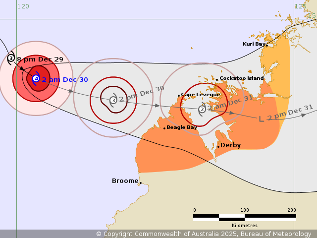
Cyclone Hayley’s predicted path as it approaches WA’s northwest coast. Photo: BOM
Communities in the Kimberley can expect increased showers and thunderstorms, heavy rain, possibly damaging winds, and a storm surge as the cyclone approaches.
Hayley is the third tropical cyclone in the Australian region this season, following Severe Tropical Cyclone Fina in November and Tropical Cyclone Grant in December.
‘Landphoon’ cuts of towns
Meanwhile, communities across Australia’s far north could be isolated for weeks as a monsoon system inches across the outback, dumping hundreds of millimetres of rain.
The monsoon system reaching from the Northern Territory into the Queensland Gulf has delivered heavy rainfall, with rising floodwaters swamping the road network and isolating small communities.
Forecaster Weatherzone said the ongoing deluge was due to a large, complex monsoonal low pressure system – “which some meteorologists call by its unofficial title of a ‘landphoon’ “.
“A ‘landphoon’ is a large low-pressure system with strong winds which resembles a tropical cyclone over land,” Weatherzone meteorologist Joel Pippard said.
“The low pressure system forms embedded in the monsoon trough and has winds wrapping into it from both hemispheres, then spinning around it. There’s a huge convergence of tropical air that leads to flooding rainfall and strong, gusty winds.”
There is a severe weather warning for practically all of Queensland’s north, from the Gulf of Carpentaria to the east coast.
Six-hourly totals of up to 260 millimetres are possible, with predictions up to 700 millimetres as the weather system moves slowly across the country.
Queensland authorities are bracing for the worst, with emergency services prepared to drop supplies to communities and livestock fodder as the system strengthens as it gradually tracks south to south-east.
“As we head into the next few days, that monsoon low and monsoon trough are very slow-moving, and the rain is expected to persist over the same area for a prolonged period,” Bureau of Meteorology forecaster Jonathan How said.
“But we will see a gradual shift with that rainfall moving further south and further east in the next few days,” he said.
He warned that the worst was yet to come as communities became isolated.
“In terms of flooding, we are expecting to see the impact last for quite some time and communities could be cut off for days if not weeks,” How said.
Major flood warnings have been issued for the Flinders River, with moderate warnings for the Cloncurry River and surrounding areas.
Sandbagging stations have opened in the Mount Isa and Hinchinbrook areas, with locals urged to take added precautions.
In the Northern Territory, warnings remain for the Barkly and Carpentaria catchments.
-with AAP
Want to see more stories from The New Daily in your Google search results?
- Click here to set The New Daily as a preferred source.
- Tick the box next to "The New Daily". That's it.


Crops flattened, towns smashed by brutal cyclone

TC Narelle to make yet another land crossing


